What al-Idrisi’s 1154 World Map Actually Shows
Understand al-Idrisi’s 1154 geography, its seventy sectional maps, south-up orientation, lost silver disk, surviving copies and modern reconstructions.
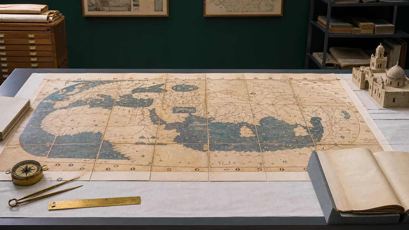
Al-Idrisi’s geography for Roger II of Sicily combined an Arabic description of the world with seventy regional map sections. The date 1154 belongs to the medieval project; the broad rectangular images circulating today usually come from later copies or modern reconstructions. The map tradition places south at the top deliberately, and the silver disk described in accounts of the commission has not survived.
The distinction between a work and a particular copy explains much of the confusion. A thirteenth-century manuscript, a nineteenth-century facsimile and Konrad Miller’s twentieth-century composite can all transmit al-Idrisi’s geography while being different objects. Their dates, lettering, missing parts and editorial changes affect what each can show.
What the project included
| Part of the project or its transmission | What it provides | What it does not establish |
|---|---|---|
| Arabic geographical text, usually called the Nuzhat al-mushtaq or Book of Roger | Descriptions of places, routes, distances, products and societies | That the author visited every place described |
| Seventy sectional maps in a seven-by-ten arrangement | A systematic way to connect regional images with descriptions | Seventy surviving maps in every individual copy |
| Small circular world maps in some manuscript witnesses | An overview within a particular manuscript | That the circular image is a photograph or exact replica of the silver disk |
| Silver cartographic disk described in the commission’s accounts | Evidence for the project’s reported material setting | A surviving object whose dimensions and drawing can be inspected today |
| Later manuscript copies and facsimiles | The evidence through which the medieval work is transmitted | A direct view of al-Idrisi’s own drawing process |
| Modern composite world maps | A convenient view assembled from regional sections | An untouched rectangular sheet made in 1154 |
The text and the maps belong together, but they carry different information. A drawing can show relationships between rivers, islands and towns. A passage can explain a journey, a crop or a settlement in ways that the image cannot. A modern composite makes the overall geography easier to see while often placing that accompanying text out of view.
Al-Idrisi at the court of Roger II
Muhammad al-Idrisi was a twelfth-century Muslim geographer associated with Ceuta, Arabic geographical learning and Roger II’s court in Palermo. Around 1100 is the conventional approximate date for his birth. His background and reported travels help explain the work’s western Mediterranean connections, but a short biography should not turn every reported movement into an equally documented eyewitness journey.
Roger’s Sicily linked Latin, Greek and Arabic traditions and occupied a strategic position between southern Europe and North Africa. Its government had reasons to seek knowledge about settlements, harbors, roads, agriculture and neighboring territories. Katherine Jacka’s study of the Book of Roger argues that the commission fitted the king’s program of authority and expansion after 1139. That is a historical interpretation of the project’s setting, rather than a surviving order giving an exact commissioning day.
The familiar starting date of about 1138 or 1139 therefore needs a qualifier. S. Maqbul Ahmad notes that no primary source specifies the year of al-Idrisi’s arrival in Sicily. Court patronage made the project possible, but its circumstances should not be flattened into either a solitary explorer’s achievement or an idealized court free of conquest and unequal power. After Roger II’s death in 1154, his successor was William I.
Why the Arabic text matters as much as the image
The title is commonly shortened to Nuzhat al-mushtaq. Book of Roger identifies the work through its patron, while Tabula Rogeriana is a Latinized label often attached to its cartographic representation. These names are useful for finding records and editions, but they do not make the long text, the regional maps, a circular overview and a modern composite identical objects.
The geography describes towns, watercourses, mountains, routes, products, agriculture and political territories. Such material matters to readers interested in how people moved and lived. A port’s place in a sailing sequence may be more informative than the modern appearance of its coastline. A description of crops or commercial goods may reveal a connection that a colored area on a map leaves unexplained.
The 2024 English translation published by Arc Humanities Press illustrates that breadth. Its scope includes the preface and selected descriptions of Sicily, southern Italy, the Adriatic and Ifriqiya. It is an introduction to substantial parts of the geography, rather than an English translation of every region in the whole work. The accompanying maps can help a reader follow the descriptions; they do not replace them.
For a particular place, the useful unit of study is the corresponding passage and map section together. Their details need not coincide perfectly. Treating the work as a manuscript system for organizing geographical knowledge describes its function without implying that it used the coordinate layers or querying methods of modern digital GIS.
How seven climates became seventy map sections
The inhabited world was divided into seven broad climatic bands, each further divided into ten sections from west to east. This produced an orderly set of seventy regional units. The term climate here belongs to the inherited geographical scheme; it is not a modern classification of rainfall, temperature or national borders.
The arrangement also suited the manuscript. Readers could move through regional sections alongside their descriptions, instead of needing one enormous sheet. A seven-by-ten composite brings those sections together in a form convenient for a wall, book spread or screen. Joining them requires choices about seams, damaged details, spelling and differences between manuscript witnesses.
The number seventy describes the intended structure, not a guarantee about the contents of every surviving copy. The BnF’s description of its manuscript Arabe 2221 identifies a Maghrebi copy of the thirteenth century and lists sixty-eight maps. A missing or incomplete part of one witness should not be turned into a different count for the original design. Conversely, a modern image showing a complete grid does not prove that a single medieval witness preserved every section intact.
Circular overview maps pose another counting problem. They occur in some copies and organize the world differently from the regional grid. They should be identified separately, rather than counted as another rectangular section or presented as the surviving silver disk. The map’s form, location in the book and manuscript identity all matter.
Reading a map with south at the top
In the familiar al-Idrisi map tradition, south occupies the top and north the bottom. East and west consequently appear on different sides from those expected on a modern north-up wall map. This changes the reader’s orientation; it does not mean that the maker accidentally placed the continents upside down.
Yale’s explanation of Miller’s reconstruction connects the south-up arrangement with the direction in which the Arabic writing is read. The labels and the map should be considered as a designed page. Simply rotating an image can make the Mediterranean easier for a modern viewer to recognize while turning the lettering away from its intended reading position.
Three orientations can therefore coexist in a reproduction’s history: the arrangement in a manuscript witness, the arrangement chosen for a modern edition and the rotation applied by the current website or publisher. Oxford’s Cabinet describes a 1929 reproduction displayed with north at the top and names transcribed into Latin characters. That presentation does not establish that all medieval witnesses were north-up.
A clear caption states the displayed direction and any rotation. A teacher can use both orientations to show how convention affects recognition, but the rotated version should retain its identification as an edited presentation. Modern north-up practice supplies a familiar point of comparison, not a universal rule against which every earlier map must be judged.
Which surviving object is being shown?
An image’s caption often supplies one date where several are needed. The original work’s compilation, the making of a manuscript, the making of a facsimile, an institution’s acquisition and a reconstruction’s publication are separate events. The following records demonstrate why the differences matter.
| Object identified by the record | Date or period specified | How to interpret it |
|---|---|---|
| BnF manuscript Arabe 2221, described in its Mediterranean teaching resource | Thirteenth-century Maghrebi copy | A later manuscript witness, with sixty-eight maps listed for this copy |
| BnF Carte générale du globe tirée d’El-Edrisi, shelfmark GE AA-2004 | Nineteenth-century manuscript facsimile; acquired in 1844 | A facsimile derived from Arabe 2221; acquisition is not its medieval composition date |
| Library of Congress Charta Rogeriana, item 2007626789 | Published in Stuttgart in 1928 | Konrad Miller’s six-sheet reconstruction, cataloged with north at the bottom |
| The accompanying title recorded for Miller’s reconstruction | Refers to restoration in 1927 | The restoration date recorded in the publication’s accompanying title |
| University of Oxford Cabinet reproduction | 1929 | A related reproduction with Latin-character names and a north-up display |
A BnF facsimile can faithfully transmit information from an older manuscript without itself becoming a medieval object. Equally, the LoC’s digitized publication can make the geography accessible without being an autograph. The catalog title and identifier make it possible to establish which object is actually being reproduced.
Dates such as 1927, 1928 and 1929 should therefore be kept with their records. They need not be forced into one universal date for every Miller-related image. An online crop may omit the title or marginal information that would identify the edition, making a return to the institutional record necessary before writing its caption.
What the lost silver disk can tell us
Accounts of the commission describe a large silver cartographic disk and a drawing board. Neither survives. Ahmad distinguishes these reported objects from the sectional maps in the book and cautions that there is no definite evidence for the story dating the disk’s loss to a coup in 1160 or 1161.
A transmitted description of weight, a modern unit conversion and a secure material measurement are different kinds of statement. Striking dimensions or destruction stories should retain their attribution and uncertainty. They cannot substitute for an inspection of an object that is no longer available.
A newly drawn silver plate is an illustration of a reported object. It can help explain the commission, provided that the caption identifies it as a reconstruction. A circular paper map or a rectangular modern composite cannot serve as a photograph of the missing disk. The text and later manuscript witnesses remain the evidence available for studying the geography in detail.
How compilation differs from a single traveler’s route
Al-Idrisi worked on a geographical scale far beyond one person’s itinerary. The work combined earlier geographical learning, reports of routes and places, knowledge available at court and the compiler’s decisions about how those materials fitted together. Personal experience belongs within that network; it does not make every description a report of something the author saw himself.
Names could reach a compiler in different spoken and written forms. A route could be remembered as a sequence of stopping places, a number of sailing days or a distance expressed in a particular unit. An account of an island might emphasize its harbor, while another emphasized agricultural produce. Bringing these reports together required comparison and judgment, and could preserve disagreements as well as solve them.
This distinction is easier to see beside a later itinerary. The account of how Ibn Battuta’s journeys became the Rihla separates travel from recollection, court-sponsored composition and the manuscript record. It offers a comparison of evidence types, not proof that Ibn Battuta contributed to al-Idrisi’s twelfth-century book.
Stories about agents sent to verify geographical reports also need attribution. They express an ambition to compare information, but an account of that ambition does not supply an independently documented size or coverage for a survey operation. The book can be read critically without turning its compilation process into a modern field-survey service or dismissing it as unthinking copying.
Accuracy depends on the question being asked
There is no useful single percentage for the accuracy of the whole project. The position of an island, the order of ports, a road distance, a town name and a statement about local products are separate claims. Each has to be tested against evidence suited to it. A shape unfamiliar to a modern reader may still preserve a meaningful route sequence; a recognizable outline can still carry an uncertain identification.
Beeston’s study of the British Isles demonstrates a local problem. Its public extract describes the seven-climate structure and discusses how earlier identifications of Arabic place names were revised, with some remaining disputed. Comparing manuscript witnesses matters because a spelling in one copy can lead to a different proposed identification from a spelling in another.
The Mediterranean and neighboring regions often provide relatively dense names and descriptions, but density is not universal precision. The distance in a text and the placement in a drawing may require different explanations. A historical name may refer to a settlement, region or route that does not map neatly onto one modern administrative label.
Al-Idrisi’s achievement is the scale and organization of a major medieval geographical compilation. It can contain detailed observations, inherited descriptions and errors at the same time. An assertion that it was the most accurate map of its age becomes meaningful only when the comparison states the region, the competing evidence and the feature being measured.
Political labels must retain their historical date
A map of medieval geography should not quietly acquire the boundaries of today’s states. A modern overlay can help readers locate a region, but the overlay and its date need to remain visible as additions. A place name or a geographical description does not automatically establish the extent of one ruler’s sovereignty.
The al-Andalus timeline provides useful western Mediterranean context. Muslim-ruled Iberian territory changed through the taifa period and the North African dynasties; the twelfth century lay within those changes. Al-Andalus cannot be drawn as one permanent country with the same outline from the eighth century to 1492. This is context for reading historical regions, rather than evidence that a later political boundary appears in the 1154 project.
West Africa supplies a different chronological check. The history of the Mali Empire places its imperial formation in the thirteenth century and explains the evidence limits around its royal centers. It would be anachronistic to label al-Idrisi’s 1154 geography with the later empire’s greatest extent or to treat a disputed capital identification as a securely mapped twelfth-century fact.
Modern thematic maps add further distinctions. Our Islamic world map resource separates population totals, population shares, majority status and OIC membership, and identifies the demographic reference year. Those are modern measures. None is a ready-made layer of medieval political authority, and a present-day population map cannot tell us the religious composition of a twelfth-century settlement.
What manuscript differences mean for interpretation
The surviving evidence includes copies made after al-Idrisi’s lifetime. Completeness, spelling, color, drawing and arrangement can differ. Missing leaves, damage, rebinding and copying decisions affect what a reader sees in a particular witness. An image should therefore be associated with a manuscript or edition before its details are treated as evidence.
This is especially relevant to an assembled world map. A reconstructing editor may draw on more than one witness or select a reading where copies differ. The completed image can appear more uniform than the material from which it was assembled. Its clean outline is a feature of the presentation, not proof that the evidence was equally complete everywhere.
A library catalog is the right starting point for an object’s shelfmark, material description, acquisition and stated date. It does not independently settle every place-name identification. A regional study can examine a geographical argument without establishing the current catalog status of every map sheet. Object records and scholarly interpretation answer different questions and work best together.
Manuscript transmission also prevents a simple equation between the oldest-looking picture and the most reliable reading. A later copy can preserve a useful detail absent from a damaged earlier witness. The task is comparison: what feature is present, which witnesses contain it, and how well does it agree with the accompanying description?
Why the completion dates should be attributed
The year 1154 remains the usual anchor for the Rogerian project. Ahmad’s discussion gives January 1154, corresponding to Shawwal 548, for the completion described in the preface. The LoC’s account likewise presents the work as the geography of 1154. These references concern the work’s medieval composition, rather than the date of a surviving facsimile or a modern reconstruction.
Accessible modern descriptions are not perfectly uniform. Beeston’s public extract uses 1153, while Arc Humanities Press’s description of its 2024 translation gives completion around 1157. Those are identifiable published statements. Their differences should be reported with attribution rather than reconciled by inventing a particular revision or publication sequence that the accessible material does not establish.
The distinction can be maintained in a concise chronology: an approximate birth around 1100; a conventionally dated commission around 1138 or 1139; the major completion associated with 1154; later manuscript witnesses; the BnF’s nineteenth-century facsimile and 1844 acquisition; and the separately documented twentieth-century reproductions. The approximate or disputed entries should remain visibly different from an institution’s stated acquisition or publication date.
How to test a dramatic claim or caption
Claims that a rotated outline represents America, Australia or Antarctica need more than resemblance to a modern coastline. A persuasive identification would require compatible names, explanatory text, a traceable manuscript history and evidence for how the information reached the compiler. The sources examined here do not establish those identifications. Stretching a shape until it looks familiar does not supply the missing evidence.
The same method applies to an apparently ordinary caption. “World map, 1154” names the historical project but may conceal that the displayed object is Miller’s publication from 1928. A more useful caption identifies the institution and item, the date of the physical copy or edition, its relationship to the medieval work, the displayed orientation and any rotation or added labels.
For a regional manuscript image, include the shelfmark and the relevant folio or climate and section. For a composite, name the reconstructor and edition. If an image has been recolored, joined or overlaid with borders, state that change. These details make it possible to follow the evidence back to an object, instead of treating a reposted picture as its own proof.
Al-Idrisi’s geography is best understood through that connection between the written work, its mapped regions and the history of its copies. Identifying the object first gives a reader a firmer basis for asking what the map shows, how its information was organized and where its limits lie.
Sources
- Library of Congress, Charta Rogeriana, item 2007626789. The catalog identifies Miller’s six-sheet publication, its 1928 date and south-up arrangement; the accompanying title records restoration in 1927. Used to distinguish the edition from the medieval project.
- Library of Congress, The Islamic World Map of 1154. The institution’s public account supports the project’s usual 1154 identification, its regional organization and the distinction between the medieval geography and Miller’s image.
- Bibliothèque nationale de France, Carte générale du globe tirée d’El-Edrisi. The object record identifies a nineteenth-century manuscript facsimile derived from Arabe 2221 and acquired in 1844. Acquisition and original composition dates are kept separate.
- Bibliothèque nationale de France, Mediterranean islands in the fourth climate, second section. The short manuscript entry identifies Arabe 2221 as a thirteenth-century Maghrebi copy with sixty-eight maps. That count describes this witness, rather than replacing the seventy-section design.
- S. Maqbul Ahmad, Cartography of al-Sharif al-Idrisi, in The History of Cartography. Pages 156–163 support the attributed completion and arrival dates, manuscript forms and silver-object caveats. The inspected scope is those eight pages, rather than the entire chapter.
- A. F. L. Beeston, Idrisi’s Account of the British Isles. The publicly accessible extract supports the regional example of disputed place-name identification and manuscript comparison. Its stated 1153 date is attributed; the paywalled full article was not used.
- Katherine Jacka, The True Nature of His Lands, in Designing Norman Sicily. The complete public summary of chapter 3 supports the author’s argument connecting the commission with Roger’s post-1139 political program and the detailed description of Sicily. The full chapter is not claimed to have been read.
- Arc Humanities Press, Al-Idrisi’s Norman Kingdom in the South. The publisher’s description and contents establish the selected scope of the 2024 English translation and its stated completion date around 1157. They do not establish a specific later-revision sequence.
- Yale University, Al-Idrisi’s Map, 1154. The public explanation was used for Miller’s reconstruction and the relationship between south-up orientation and Arabic lettering. Its biographical statements were not relied on.
- University of Oxford Cabinet, Tabula Rogeriana. The short object explanation identifies a 1929 reproduction with Latin-character names and a north-up presentation. It is treated as that particular reproduction, rather than a date for every modern composite.


