Who Founded Baghdad? The 762 Round City Explained
How al-Mansur founded Baghdad in 762: the Round City's plan, four gates, construction, urban expansion, historical evidence and enduring myths.
This distinction solves several apparent contradictions. Baghdad can be “founded” in 762 even though the name and a settlement existed earlier. A circular plan can be central to its history even though most residents soon lived outside the circle. And historians can describe the plan in detail even though no visible buildings from al-Mansur’s enclosure survive: the plan is reconstructed chiefly from medieval texts, not excavated street walls.
Baghdad’s foundation at a glance
| Question | Evidence-based answer |
|---|---|
| Who founded Baghdad? | Abu Ja‘far al-Mansur, the second Abbasid caliph, who ruled from 754 to 775. |
| When? | Work began in 145 AH / 762 CE; the principal complex was built in stages over the following years, conventionally summarized as 762–766. |
| Where? | On the western bank of the Tigris in central Iraq, near waterways linking the Tigris and Euphrates systems. |
| What was it called? | The official name was Madinat al-Salam, the City of Peace. Baghdad, an older local name, became the ordinary and enduring name of the metropolis. |
| Was all Baghdad round? | No. The circle was the original caliphal and administrative core. The lived city quickly spread beyond it. |
| What survives? | No above-ground fabric securely identified as al-Mansur’s Round City. Its layout is a critical reconstruction from written sources. |
What was at Baghdad before 762?
Calling al-Mansur the founder does not mean that he selected an uninhabited desert. Medieval evidence preserves the name Baghdad before the Abbasid project, and an Encyclopaedia Iranica synthesis notes a market settlement attended by merchants before the new capital was built. The exact etymology of “Baghdad” is debated, so confident translations of the name should be treated cautiously. What is clear is the historical scale of the change: al-Mansur did not invent the place-name, but he transformed the site into the seat of an empire.
The distinction between an older locality and a planned imperial foundation is common in urban history. “Founded in 762” means the start of the Abbasid capital and its monumental administrative complex. It does not claim that no one lived, traded or cultivated land in the area before that date.
Why did al-Mansur choose this site?
The Abbasids had overthrown the Umayyads in 750 with decisive support from Khurasan and Iraq. Damascus remained identified with their predecessors, while a purpose-built capital allowed the new dynasty to organize court access, military security and administrative space on its own terms. The region also placed the caliph near the older Mesopotamian imperial landscape, including the Sasanian capital zone around Ctesiphon, without simply occupying an Umayyad center.
Geography mattered as much as symbolism. Al-Ya‘qubi’s later account praises the site because goods could reach it by land and water from many directions. The Tigris led toward the Persian Gulf; canal and river systems connected agricultural districts and the Euphrates; overland routes pointed toward Iran and Central Asia, northern Mesopotamia, Syria and Arabia. A capital of officials, soldiers, artisans, servants and dependants required grain, building materials, animals and fuel every day. The site’s value lay in provisioning and communication, not merely in a visually dramatic circle.
Political control also mattered. Al-Mansur’s first years were marked by rival claims and rebellion. A new, guarded court city gave him physical distance from established constituencies in Kufa while remaining near Iraq’s productive and commercial networks. No single motive is sufficient: the decision combined dynasty-building, security, transport, taxation, food supply and imperial display.
Did astrologers choose the foundation day?
Sources associate the astrologers Nawbakht and Masha’allah with selecting an auspicious moment for the foundation, commonly converted to 30 July 762. Astrology was part of learned court practice in the period, so the report is not inherently implausible. It should nevertheless be used with precision. The astrological election may explain the ceremonial timing of construction; it does not by itself explain why central Iraq was chosen, how labor was organized or why the city grew.
Exact day conversions can differ because Islamic lunar dates, manuscript readings and modern chronological calculations do not always align. For a general history, 145 AH / 762 CE is the secure anchor. A precise hour should be attributed to a named textual or astronomical reconstruction rather than presented as if a modern construction log survived.
How was the Round City laid out?
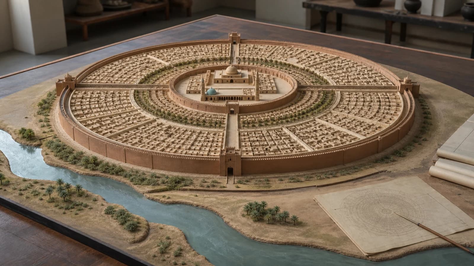
Medieval descriptions portray Madinat al-Salam as a vast circular—or at least strongly rounded—enclosure surrounded by a moat and successive defensive barriers. The word used by al-Ya‘qubi, mudawwara, is normally read as circular, although scholars have discussed what degree of geometric precision it implies. Published estimates often place the diameter around 2.5 kilometers, but the figure depends on how a textual cubit is converted and which reported circumference is accepted. It is better understood as an approximate reconstruction than a surveyed measurement.
Four monumental gate complexes opened into the enclosure. From them, broad roofed or arcaded avenues led inward. Light wells helped illuminate sections described as covered with baked brick. Within the rings of defenses and circulation were residential and service spaces assigned to members of the court, commanders and groups attached to the regime. At the center lay a large controlled precinct containing the caliph’s palace—often called the Golden Gate Palace—and the congregational mosque.
The plan made political hierarchy visible. Travelers entered from the empire’s great routes, passed through layered defenses and approached a center occupied by caliph and mosque. Yet a diagram should not be mistaken for a complete map of everyday life. Medieval texts emphasize gates, palaces and ceremonial movement more readily than drains, workshops, kitchens, women’s spaces, temporary buildings or the homes of ordinary laborers.
The four gates and the regions they faced
| Gate | Approximate quadrant | Route and political meaning |
|---|---|---|
| Bab al-Kufa | Southwest | Faced the road toward Kufa, an early Iraqi garrison city and major political-religious center. |
| Bab al-Basra | Southeast | Pointed toward Basra and routes feeding into southern Iraq and Gulf commerce. |
| Bab al-Sham | Northwest | Opened toward al-Sham, greater Syria, the region of the former Umayyad capital. |
| Bab Khurasan | Northeast | Faced Khurasan, the region whose soldiers and networks had been crucial to the Abbasid Revolution. |
The names were geographical and ideological. They placed the new court at the meeting point of major imperial directions. They do not mean that each gate followed a perfect modern compass bearing or that every traveler from a named region used only that entrance.
Who built the city, and what was it built from?
Later chronicles describe an enormous mobilization of architects, surveyors, craftsmen and laborers from across the caliphate. Their headline totals and construction costs vary and are not independently auditable, but the basic inference is sound: a fortified court city of this scale required centralized procurement and a large, specialized workforce. The palace, mosque, gates, walls, roads, water supply and housing were not one building project but a coordinated field of projects.
Central Mesopotamia favored brick construction. Mud brick was readily available but needed maintenance; fired brick was more durable and more expensive and was therefore used selectively. Timber, reeds, gypsum and reused or transported materials also belonged to the building economy. This material setting helps explain both the speed with which large forms could be raised and the poor survival of the eighth-century fabric beneath a continuously inhabited modern city.
Why the Round City did not remain the whole city
Madinat al-Salam began as a palace, administrative and elite residential enclosure. A successful capital, however, attracted far more people and activities than its controlled center could contain. Al-Mansur transferred markets from inside the circle to Karkh to the south. Whatever the exact combination of security, congestion and fire concerns in the narrative sources, the consequence was decisive: commercial gravity strengthened outside the walls.
Harbiyya developed to the north and northwest, with military and residential groups including Khurasani supporters of the Abbasids. Across the Tigris, Rusafa grew around the establishment associated with al-Mansur’s son and heir al-Mahdi. Palaces and gardens also followed the river; al-Mansur used al-Khuld near the Khurasan Gate and the Tigris. Bridges, canals and boat traffic joined districts whose fortunes shifted with fires, floods, civil conflict and court preference.
By “Baghdad,” medieval authors could therefore mean several overlapping things: the Round City, western-bank districts, eastern Baghdad, or the whole metropolitan agglomeration. Population claims are meaningless unless the boundary and date are stated.
Was Baghdad really a city of one million people?
Baghdad was unquestionably among the largest and most consequential cities of its age, but no Abbasid census gives a secure metropolitan total. Modern estimates have been built from reported dimensions, housing density, food supply, bath or mosque counts and comparisons with other premodern cities. Each method depends on uncertain assumptions, and medieval numbers may be rhetorical or refer to different urban boundaries.
The popular figure of one million should therefore be labeled an estimate, not a measured fact. It may refer to the wider metropolis at a later peak, not the Round City of 762. The historically useful conclusion is qualitative but still important: Baghdad became a very large polycentric capital whose population far exceeded the capacity of the original palace enclosure.
How do we know the plan if the Round City is gone?
Al-Mansur’s enclosure has not survived above ground, and the densely occupied modern city makes systematic excavation exceptionally difficult. The main evidence is literary. Al-Ya‘qubi, writing in the later ninth century, provides an influential topographical description. Al-Khatib al-Baghdadi in the eleventh century preserved additional traditions. Al-Tabari and other historians recorded foundation narratives and political events. These writers were knowledgeable, but none supplied a contemporary architectural survey created for modern historians.
Guy Le Strange’s 1900 study arranged medieval Arabic and Persian notices into maps that remain widely reproduced. Later scholars including Ernst Herzfeld, K. A. C. Creswell and Jacob Lassner proposed different readings of walls, courtyards, gate halls, arcades and the central complex. A 2016 architectural analysis demonstrates that even precise-looking reconstructions disagree with one another and with parts of the written descriptions.
That does not make the Round City imaginary. It means confidence must be graded. The founder, 762 date, official name, broad circular concept, four named gates and central palace-mosque zone are strongly supported. Exact wall profiles, every building footprint and a single meter-perfect diameter are less secure. Responsible captions say “reconstruction based on medieval descriptions.”
Madinat al-Salam, Baghdad and the evidence of coins
The relationship between the two names is not a choice between “true” and “false.” Madinat al-Salam was the official, ideologically resonant name of the foundation and mint. Baghdad was the older local name that became dominant in ordinary geographical usage. A British Museum silver dirham of al-Mansur dated 150 AH / 767 states that it was minted at Madinat al-Salam. That is direct material evidence for official usage only a few years after construction began.
A coin cannot prove the walls were circular, but it can anchor a name, mint, ruler and date. This is a useful example of historical method: objects and texts should corroborate the claims they are capable of testing, rather than being asked to validate an entire story at once.
Did Baghdad’s Golden Age begin in 762?
The foundation created conditions that later favored scholarship: concentrated patronage, tax revenue, book markets, paper production, multilingual communities and routes linking courts and scholars. But algebra, medicine, astronomy and the translation movement did not appear fully formed when the first foundations were laid. Major activity expanded under later caliphs and through the work of translators, physicians, mathematicians, copyists, merchants and patrons operating in many settings.
The House of Wisdom is especially vulnerable to anachronism. Recent scholarship describes it more cautiously as an Abbasid caliphal library or collection whose name and functions changed, not a modern university with permanent faculties where every famous scholar worked. Harun al-Rashid and al-Ma’mun belong to the later eighth and early ninth-century context. Linking their age to Baghdad is valid; placing a fully developed academy in al-Mansur’s central palace in 762 is not.
Baghdad after the first Abbasids: 836, 892 and 1258
In 836 the caliph al-Mu‘tasim established the court at Samarra, about 125 kilometers north on the Tigris. Eight caliphs resided there until 892. Baghdad did not cease to be a major commercial, religious and intellectual city during this interval, and the court eventually returned. Samarra’s extensive archaeological remains are valuable precisely because they preserve evidence that early Baghdad largely cannot.
Baghdad continued to change under later Abbasid, Buyid and Seljuk power. The Mongol army of Hülegü captured the city in 1258, killing the caliph and causing massive destruction and loss of life. The event ended the Abbasid caliphate in Baghdad, but it did not erase every building, book or inhabitant, nor did all learning in the Islamic world depend on one city. Baghdad remained inhabited and historically important after the conquest.
Common claims: what the evidence actually supports
| Popular claim | Better-supported formulation |
|---|---|
| “Harun al-Rashid founded Baghdad.” | Al-Mansur founded the imperial city in 762. Harun al-Rashid ruled later, from 786 to 809. |
| “There was nothing there before 762.” | An older Baghdad place-name and market settlement predated the Abbasid capital. |
| “All medieval Baghdad was a perfect circle.” | The Round City was the original court core; the metropolis quickly spread across multiple districts and both riverbanks. |
| “The surviving map is an archaeological survey.” | Familiar plans are modern reconstructions based mainly on later medieval texts. |
| “Exactly one million people lived inside the circle.” | No secure census exists. Large estimates usually concern the later, wider metropolis. |
| “The House of Wisdom opened with the city in 762.” | Caliphal book collections and translation networks developed later; the institution’s form is debated. |
| “The Mongols made Baghdad disappear forever.” | The 1258 conquest was catastrophic and ended the local Abbasid caliphate, but the city survived and was rebuilt. |
Frequently asked questions
Who founded Baghdad?
The second Abbasid caliph, Abu Ja‘far al-Mansur, founded the new imperial capital. Earlier settlements existed in the area, but his 762 project created Madinat al-Salam and the core from which Abbasid Baghdad grew.
What year was Baghdad founded?
Construction began in 145 AH / 762 CE. “762–766” is often used for the main construction phase, but the metropolis continued building and rebuilding for centuries.
Why was Baghdad circular?
The geometry concentrated authority and controlled approaches to the palace-mosque center. Scholars also discuss Iranian urban precedents and cosmological symbolism, but no single surviving design brief tells us one exclusive reason.
What were Baghdad’s four gates?
They were the gates of Kufa, Basra, al-Sham or Syria, and Khurasan. Their names oriented the capital toward major regions and roads of the Abbasid world.
Can the Round City be visited today?
Not as a standing archaeological monument. Its location lies within modern Baghdad, and no above-ground ensemble of al-Mansur’s walls and palace survives. Museum objects, texts and scholarly plans must be used to understand it.
Was the city officially called Baghdad?
Madinat al-Salam was the formal foundation and mint name, while Baghdad was the older place-name that became the everyday name. Both are historically correct when their contexts are explained.
Was Baghdad always the Abbasid capital after 762?
No. The court resided at Samarra from 836 to 892. Baghdad remained important and again became the caliphal seat after the Samarra period.
What is Baghdad’s most important urban legacy?
Its legacy is not only the striking circular diagram. Baghdad joined imperial administration, river transport, markets, diverse populations and later scholarly patronage into a metropolis that became a reference point across Afro-Eurasia.
Continue researching Abbasid Baghdad
- The Abbasid Revolution, 747–750: Understand how the new dynasty took power before al-Mansur selected Baghdad.
- The House of Wisdom: history and myths: Separate the caliphal library from the later image of a single universal academy.
- Al-Khwarizmi, algebra and algorithms: Follow one scholar connected with ninth-century Abbasid patronage.
- The fall of Baghdad in 1258: Continue the city's history through the Mongol siege and its disputed stories.
- The Abbasid barid postal and intelligence network: See how information and orders moved across the empire governed from Iraq.
- Papermaking from Samarkand to Baghdad: Trace materials, workshops and book culture without a one-battle origin myth.
- Islamic Golden Age: evidence-based timeline: Place Baghdad's later scholarly networks in a dated institutional history.
- Islamic history timeline: Connect the 762 foundation to the broader political chronology.
Sources
The article distinguishes contemporary material evidence, later medieval descriptions and modern scholarly reconstructions. These sources do not all answer the same question.
- Smarthistory: The founding of Baghdad: Best accessible synthesis of the site choice, Yaqubi's description, four gates and growth outside the circle.
- Cambridge World History: Baghdad, an imperial foundation (762–836 CE): Academic overview of the palatial foundation and the fast-changing metropolis between 762 and 836.
- IRAQ: Images of Round Baghdad—an analysis of reconstructions: Architectural study showing why familiar modern plans differ and why details remain interpretive.
- Encyclopaedia Iranica: Baghdad before the Mongol invasion: Reference overview of Baghdad's Abbasid history and its Iranian and Khurasani connections.
- Encyclopaedia Iranica: Iraq in the late Sasanid and early Islamic eras: Evidence for the older Baghdad place-name, a pre-762 market and Iraq's early Abbasid setting.
- Encyclopaedia Iranica: Bazaar—organization and function: Specific evidence that al-Mansur transferred the markets from the Round City to Karkh.
- Encyclopaedia Iranica: Abu Sahl Nawbakht: Biographical evidence linking Nawbakht and Masha'allah to the reported July 762 astrological election.
- The Metropolitan Museum of Art: The Art of the Abbasid Period: Museum overview of the eastward Abbasid shift, Baghdad's 762 foundation and the Samarra interval.
- British Museum: al-Mansur dirham minted at Madinat al-Salam in 767: Catalog record for a 767 silver dirham minted at Madinat al-Salam; material evidence for the official name.
- UNESCO World Heritage Centre: Samarra Archaeological City nomination dossier: Comparative evidence from the surviving Abbasid city of Samarra and the 836–892 court residence.
- Routledge: The Abbasid House of Wisdom—Between Myth and Reality: Recent history-of-science study testing the popular House of Wisdom narrative against the sources.


