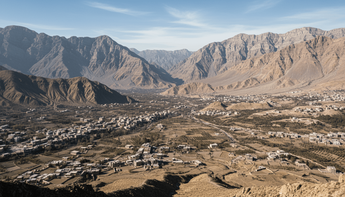
Quetta City: History, Geography, Population and Culture
A documented guide to Quetta, the capital of Balochistan, covering its mountain basin, 2023 census context, transport role, 1935 earthquake, communities, food and nearby Hanna Lake.
Quetta is the provincial capital and the main administrative, educational and commercial centre of Balochistan. Searches for the city often mix Quetta district, Quetta division, the metropolitan corporation and the continuously built urban area. They also compress its story into fruit markets, one earthquake or a gateway slogan. A better guide begins with geography: a high basin surrounded by ranges, connected through difficult corridors and dependent on limited water. It then reads population from the 2023 census, treats the 1935 earthquake as a documented turning point, and describes Baloch, Pashtun, Hazara and other communities without assigning the whole city one identity.
Key points
- Quetta city, district and division are different units; population figures must identify which boundary they use.
- The highland basin shapes climate, water supply, orchards, transport and the direction of urban growth.
- The 1935 earthquake changed the built city, but Quetta's history extends before and after that disaster.
- Current security, road and weather conditions are time-sensitive and should be checked through authorities rather than frozen into an evergreen guide.
A highland capital in a mountain basin
Quetta lies in a high basin near Pakistan's western frontier, with mountain walls giving the city a distinctive horizon and constraining expansion. Its elevation produces colder winters than many Pakistani cities, while aridity limits dependable surface water. The basin is connected southward toward the Bolan corridor and outward to border, provincial and national routes. This setting helps explain Quetta's importance as both a provincial capital and a transport market.
The same terrain creates risk. Drainage, groundwater recharge, seismic construction and long supply routes all matter to urban planning. The provincial Water Policy describes wider stress on groundwater and variable rainfall. A travel article that celebrates orchards without acknowledging water limits tells only half the story; an environmental article should likewise avoid treating every part of the basin as identical.
Reading Quetta's population correctly
The Pakistan Bureau of Statistics 2023 census is the baseline for current population research, but the word Quetta can refer to several boundaries. The provincial report separates administrative units and urban–rural classifications. Before quoting a total, check whether the table covers a district, municipal area, cantonment, tehsil or division. Search snippets frequently omit that label.
Urban growth reflects natural increase, movement from other districts, education, public employment, trade and displacement. Census numbers describe counted residents under stated definitions; they do not by themselves identify ethnicity, household security or permanent intention to remain. Comparing 2017 and 2023 also requires checking whether boundaries and urban classifications stayed consistent.
History before and after the 1935 earthquake
Quetta developed as a regional settlement and later as a strategic railway, cantonment and administrative centre under British rule. Routes through the Bolan Pass and toward Afghanistan made the basin important long before modern aviation. Colonial records, however, represent the priorities of the administration that produced them; local family histories, religious institutions and markets add perspectives absent from official gazetteers.
The destructive earthquake of 31 May 1935 is essential to the modern city's history. It killed many residents and led to new building controls and reconstruction. The event should be dated and sourced rather than used as a dramatic adjective for every later neighbourhood. Post-earthquake Quetta continued to grow, absorbing new communities and institutions whose histories cannot be reduced to the disaster.
Communities, languages and everyday culture
Quetta's public life is multilingual. Pashto, Balochi, Brahui, Urdu, Hazaragi and other languages can appear in homes, schools, worship, commerce and media. Community concentration varies by neighbourhood, but no single bazaar or festival represents the whole city. Write at the level of a named institution, family, craft workshop or recorded event rather than attaching one custom to all Quetta residents.
Mosques and Islamic calendars shape much everyday rhythm for Muslim communities, while the city also contains minority histories and religious places. Food offers another point of connection: Sajji is associated with Balochistan, yet restaurant versions in Quetta can differ from rural preparation and from versions sold elsewhere in Pakistan. The distinction between regional origin and one standardized recipe should remain visible.
Hanna Lake, Hanna–Urak and nearby landscape
Hanna Lake and the Hanna–Urak area are commonly presented as Quetta excursions. Provincial policy lists Hanna Lake among important wetlands, and development programmes record public projects in the area. Neither source guarantees a constant water level, open facilities or safe road access on a particular day. Visitor information must therefore be checked against current local notices.
The lake is best understood within the basin's water history rather than as an isolated blue landmark. Rainfall, catchment management, sediment, drought and infrastructure affect what visitors see. The separate Hanna Lake guide explains those conditions and shows why old promotional photographs should never substitute for a dated observation.
A reliable Quetta research and travel checklist
For stable facts, use the provincial government, Bureau of Statistics and census reports. For an institution, consult its own current page. For transport, opening hours, weather or security, verify close to the intended date with authorities and local operators; do not infer present conditions from an evergreen article. Keep city, district and division labels in every note.
Follow the topic links directly: the Balochistan guide supplies provincial scale, Bolan explains a major route, Hanna covers the nearby water landscape, and the Sajji and dress pages examine cultural practices with object-level sources. These links produce a legible city–region relationship without making Quetta stand in for the entire province.
How to read the evidence
Official statistics, government plans, UNESCO submissions, museum records and tourism pages answer different questions. Keep each source's geography, reference date, institutional role and uncertainty visible. Current access, weather, transport and security conditions must be checked close to the intended date.
Related Balochistan reading
- Balochistan Province: Map, Districts, Population and Geography
- Hanna Lake, Quetta: History, Water Conditions and Visitor Context
- Bolan Pass: Geography, History and the Route to Quetta
- Sajji: Balochistan Food, Preparation, History and Regional Variations
- Balochi Traditional Dress: Embroidery, Pashk and Cultural Context
Sources
These sources are linked for verification. A UNESCO Tentative List entry is not a World Heritage inscription, a budget line is not proof of completion, and an institutional plan is not an observed outcome.
- Government of Balochistan — Provincial portal — Official provincial overview and government information, including the province's area and administrative context.
- Balochistan Bureau of Statistics — Statistics and district profiles — Official statistics hub with district profiles and provincial indicators; administrative listings may post-date the 2023 census reference date.
- Pakistan Bureau of Statistics — 2023 Census — Official census hub for definitions, reports, tables and the 2023 reference period.
- Pakistan Bureau of Statistics — Provincial Census Report 2023: Balochistan — Official provincial report describing census geography, population and settlement patterns at the reference date.
- Government of Balochistan — Balochistan Water Policy 2024 — Provincial policy evidence on aridity, water management and wetlands, including Hanna Lake.
- Government of Balochistan — Public Sector Development Programme 2023–24 — Official programme record for tourism and public works at Hanna–Urak, Kund Malir and other provincial sites.


