Gwadar Port: History, CPEC, Master Plan and Local Context
A fact-checked guide to Gwadar Port on the Arabian Sea, separating completed facilities, operating arrangements and dated milestones from CPEC projections and long-range master-plan claims.
Gwadar Port attracts searches about shipping, CPEC, China, the Strait of Hormuz and Pakistan's economic future. Much of the online material repeats projected capacity as if it already existed. The Gwadar Port Authority provides a more disciplined starting point: a coastal location in Balochistan, a long-range master plan, operations assigned in 2007 and a concession transferred in 2013. Those institutional milestones do not settle questions about cargo volumes, local livelihoods, water, fisheries or future construction. This guide separates the port, the city, the district and the wider Gwadar development programme, and it labels plans as plans.
Key points
- Gwadar Port, Gwadar city, Gwadar district and the wider CPEC programme are related but distinct entities.
- The authority's 50-year master plan is a planning framework; future phases and stated capacity are not completed facts.
- Operator, concession, ownership, financing and sovereignty are different legal concepts and should not be collapsed into one headline.
- Local water, fishing access, employment and urban services are essential context for evaluating development outcomes.
Where the port sits and why location matters
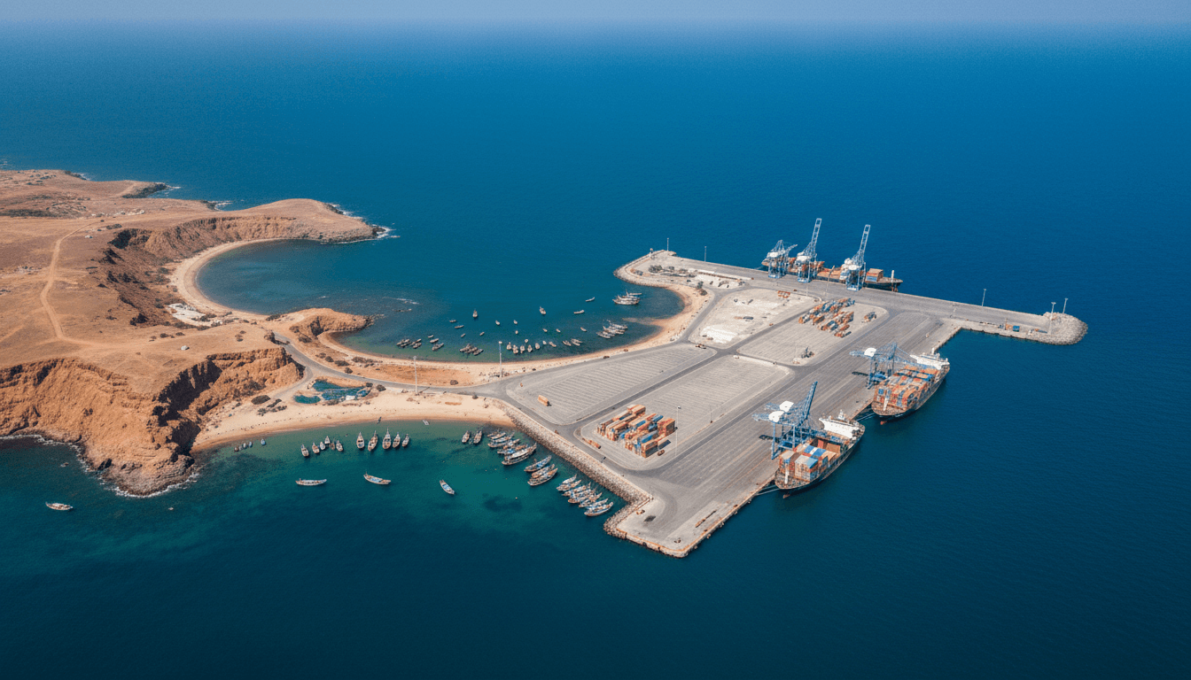
Gwadar lies on Pakistan's Arabian Sea coast in Balochistan, on a distinctive hammerhead-shaped peninsula with bays on either side. Port Authority materials emphasize its proximity to shipping routes leading toward the Gulf and the Strait of Hormuz. Geographic proximity can create strategic interest, but it does not automatically produce traffic, trans-shipment or industrial demand. Those outcomes depend on terminals, hinterland connections, costs, policy and customers.
The port should not be confused with the entire coastal city. Fishing settlements, residential areas, beaches, airport infrastructure and planned development occupy different spaces and serve different users. Maps that shade the whole peninsula as a port erase local land use. A reliable map names the port boundary, city, district, roads and proposed zones separately.
A dated institutional history
The Gwadar Port Authority's master-plan page states that a 50-year plan was approved in 2006, that port operations were assigned in 2007, and that the concession was transferred in 2013. These are useful dated milestones. Earlier coastal and political history belongs in a broader Gwadar history, but it should not be forced into a simple story that makes the modern port inevitable.
A concession gives an operator defined rights and responsibilities under agreements; it is not the same as transferring national territory. Likewise, construction financing, management, terminal operation and ownership of equipment can involve different bodies. Articles should quote the precise arrangement and date instead of using vague phrases such as owned by or given away.
CPEC and the difference between projects and outcomes
Gwadar is widely presented as a component of the China–Pakistan Economic Corridor. CPEC is a portfolio of transport, energy, industrial and urban projects rather than one road or one contract. A project can be proposed, approved, financed, under construction, operational or revised. Those stages require separate evidence. An artist's rendering or master-plan land-use map proves a proposal, not delivery.
Port performance should be evaluated with dated operational measures such as vessel calls, cargo type, tonnage, berth use and hinterland movement. Institutional mission statements describe intended roles. They should be attributed to the authority and compared with actual data rather than repeated as forecasts guaranteed to occur.
Master plan, airport and urban development
Long-range planning coordinates port expansion with roads, logistics, industrial areas, housing and services. The published master-plan chronology is valuable for understanding the framework, but plans change as land, finance, environment and demand change. Always record the plan version and approval date. Do not merge a later airport opening or road project into the status of a port terminal.
Urban growth also creates questions about water, electricity, waste, land prices and access to public space. An infrastructure project can be complete while a neighbourhood service remains inadequate. Evaluation needs city and household evidence alongside construction milestones. The 2023 census report provides demographic context but not a satisfaction survey or a real-time service dashboard.
Fishing communities and local economic claims
Gwadar's coast supported fishing and maritime livelihoods before the modern port. Development can create jobs and markets while also changing landing sites, road access, security boundaries and marine conditions. Claims about benefit or harm should name the community, time period, method and affected activity. One interview cannot provide a district-wide percentage, but it can document a lived experience that aggregate cargo data cannot show.
Employment figures require equal care. Announced jobs, construction labour, permanent port positions and indirect businesses are different categories. Record whether a figure is a target or observed payroll and whether it counts local residents. That distinction matters to both supporters and critics of the project.
How to verify a Gwadar claim
Begin with the Port Authority for institutional chronology and current official descriptions. Then look for dated operator notices, government budgets, audited statistics, port-call data and census geography. Label forward-looking language clearly. If a source says planned, envisioned, expected or designed for, preserve that status in the article.
Connect Gwadar directly to the Balochistan provincial guide and the Kund Malir–Hingol coast page. The former supplies census and administrative scale; the latter keeps port development distinct from the protected and pilgrimage landscapes farther east. Quetta and Bolan links explain inland political and transport context without pretending that every corridor is already a seamless freight route.
How to read the evidence
Official statistics, government plans, UNESCO submissions, museum records and tourism pages answer different questions. Keep each source's geography, reference date, institutional role and uncertainty visible. Current access, weather, transport and security conditions must be checked close to the intended date.
Related Balochistan reading
- Balochistan Province: Map, Districts, Population and Geography
- Kund Malir and Hingol: Makran Coast, National Park and Pilgrimage Landscape
- Bolan Pass: Geography, History and the Route to Quetta
- Quetta City: History, Geography, Population and Culture
Sources
These sources are linked for verification. A UNESCO Tentative List entry is not a World Heritage inscription, a budget line is not proof of completion, and an institutional plan is not an observed outcome.
- Gwadar Port Authority — Official portal — First-party port information; statements of mission and future capacity are plans or institutional claims rather than completed outcomes.
- Gwadar Port Authority — Master plan history — Official chronology of the long-range master plan, 2007 operations assignment and 2013 concession transfer.
- Gwadar Port Authority — About Gwadar — First-party description of Gwadar's coastal setting, district history and planning context.
- Government of Balochistan — Provincial portal — Official provincial overview and government information, including the province's area and administrative context.
- Pakistan Bureau of Statistics — Provincial Census Report 2023: Balochistan — Official provincial report describing census geography, population and settlement patterns at the reference date.
- National Tourism Portal — Tourist attractions in Pakistan — Official national attraction directory with Balochistan entries including Hingol and Gwadar.


